Orographically amplified wind loss models for Hawaii and Pacific insular states
 
Island Selection
Guam
Kauai
Lanai
Molokai
Oahu
Future work is anticipated to develop maps for Maui and Hawaii.
Peak, Mean or Composite
Directional Peak Wind Speed-up
Directional Mean Wind Speed-up
Maximum Peak Wind Speed-ups
Maximum Mean Wind Speed-ups
Wind Direction Selection
22.5° 45.0° 67.5°
90.0° 112.5° 135.0° 157.5°
180.0° 202.5° 225.0° 247.5°
270.0° 292.5° 315.0° 337.5°


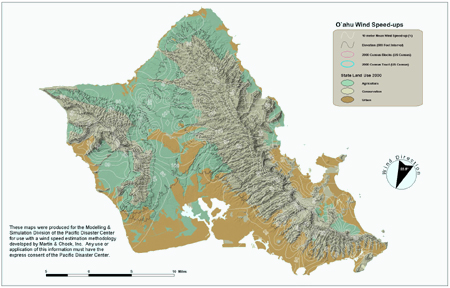
These products are intended for and should only be used by weather forecasters or meteorologists. The products show the influence of terrain on amplifying the winds. The amplified winds or wind speed-up factors are expressed as percents. To determine the actual winds or potential wind damage from a tropical cyclone would require linking the wind speed-up information to a windfield model.